From Boundaries to Blueprints: How Surveying Shapes Construction Projects

Surveying, the unsung hero of civil engineering, holds the key to successful project execution. Imagine you're planning to undertake a construction project on a piece of land. Before the project can begin, surveying becomes essential. Surveyors will visit the site and gather important information about the land. They intend to assess and chart the property's limits for the purpose of establishing its precise dimensions and configuration. This ensures that you know precisely where your land starts and ends. Surveying also helps in understanding any legal requirements or restrictions related to your property.
Additionally, surveyors will examine the topography of the land, which means they'll assess its slopes, contours, and any natural features like rivers or hills. This information holds utmost significance in establishing the foundation of your project, guaranteeing its stability and precise alignment. Surveyors may also identify any existing infrastructure near your land, such as utility lines or drainage systems. This knowledge helps in planning the construction process and ensuring that your project is properly connected to necessary services.
By conducting surveys and collecting data, surveyors create detailed maps or plans that provide a comprehensive overview of the land. These maps serve as a guide for architects, engineers, and construction teams, helping them make informed decisions about the design, layout, and placement of your project. From majestic dams to bustling roadways, high-rise buildings to railway networks, pipeline installations to tunnel construction, and town and urban planning, surveying plays a pivotal role in shaping the built environment. Presented below is a selection of survey plan examples for your reference.
The ABCs of Surveying: Three Main Functions You Need to Know
- Finding the positions of points: Surveyors measure and determine how points relate to each other, both horizontally and vertically. By doing this, they help us understand the exact locations of these points on the land.
- Making sense of the data: Surveyors process and interpret the measurements they collect to make them useful. They transform raw numbers into meaningful information that can be understood and utilised by architects, engineers, and construction teams.
- Setting markers for construction or land boundaries: Surveying plays a crucial role in construction projects by establishing markers that guide builders. These markers serve as reference points during the construction process, ensuring that structures are positioned correctly and according to the design plans.

Types of Survey Machines for Construction Purposes in India: Enhancing Accuracy and Efficiency
Surveying instruments are essential tools that enhance the accuracy and efficiency of construction projects. They enable surveyors to gather precise measurements and data, providing the foundation for successful project execution. Here are some of the common survey instruments used in construction:
Total Station
Total station is one of the most primary devices that is regularly used in mining surveying. It integrates electronic distance measurement (EDM) capabilities with theodolite functions. EDM helps in measuring the distance between two points by considering the changes on the electronic energy waves as it travels from one point to another. Theodolite correctly measures the vertical and horizontal angle. It can rotate freely along the vertical as well as horizontal axis.
The combination of these two enable surveyors to achieve exceptional accuracy when measuring angles, distances, and elevations all in a single tool. Total stations are used for various construction applications, including setting out building foundations, aligning structures, and determining vertical heights.

Theodolite
Theodolite is known for being a precise angle measuring instrument. The theodolite is used in crucial operations like navigating, meteorology, forming panels, aligning wood frame walls, plumbing a column or building corner. Theodolites come with an internal optical device, which contributes to the correctness of the reading. It is also an efficient instrument as it allows comparatively lesser repeat readings.
Theodolites have been a staple in construction surveying for years. There exist two categories of theodolites: digital and non-digital. In contemporary times, digital theodolites have gained widespread usage. Digital theodolites feature a telescope mounted on a base and as an electronic readout screen for convenient display of the results.

Laser Level
A laser level is an initial instrument utilised for the purposes of levelling and aligning.Two of the most common uses for laser levels are establishing an absolute point and elevations. The device emits a laser beam that acts as a visual reference, allowing construction workers to ensure straightness and levelness for elements like walls, floors, and ceilings. The laser beam creates an absolute point which acts as a reference point that does not move at all. In simpler words, it is similar to using a flag to mark a stationary, fixed spot on the ground. This point can be used as a reference to the starting point with respect to which measurements can be made.
Laser levels significantly reduce human labour and increase the correctness of the measurement. To divide further, there are two types of laser levels, namely liner lasers and rotary lasers. Laser levels are commonly used in construction tasks such as installing tiles, framing, and aligning structural components.

Dumpy Level
Dumpy levels, also known as automatic levels or builder’s levels, are extensively used in construction surveying. It is commonly used to calculate elevation of different points or distance between two points on the same horizontal plane. It is a rather compact device that is easy to carry around. These instruments provide horizontal levelling by utilising a telescope and a spirit level.
The accuracy it provides makes it commendable. A dumpy level has the capacity to achieve an accuracy of 1:4000 for every 100 metres. In addition to its precise accuracy, it is extremely safe to use and an economical option. Making adjustments on the instrument is easy. Dumpy levels are effective for establishing benchmarks, determining ground profiles, and ensuring accurate grading during construction.

GPS (Global Positioning System)
GPS technology has revolutionised surveying in construction. It is undeniable that civil engineers work in unfriendly and complex environments. GPS has made working in these complex environments easy and accessible. Specially in situations like road construction, wireless communications and computer systems that make operating and processing easy. In addition to road construction, GPS is also great for Earth moving and fleet management.
The main contribution of GPS to civil engineering has been its ability to provide real-time submeter and centimetre level accuracy. This makes GPS receivers utilise signals broadcasted by satellites to accurately determine locations on the Earth's surface. This technology allows surveyors to efficiently establish control points and accurately position construction elements. Real-Time Kinematic (RTK) GPS systems offer centimetre-level accuracy, making them invaluable for large-scale construction projects.

GNSS (Global Navigation Satellite System)
GNSS is an umbrella term that includes GPS as well as other satellite navigation systems like GLONASS, Galileo, and BeiDou. GNSS is mostly used in grade control and machine control. It increases the accuracy of the machine positioning and guides equipment according to the project plans. Beyond these, it also contributes to excavating, piling, paving, compacting, drilling, scraping, and dozing.
Using GNSS effectively can cost significantly less than employing human labour for any traditional site operation. GNSS also makes it possible to keep track of multiple construction sites conveniently and correctly. Since it directly links to the satellites and collects data about the construction site, the chances of transmission error is highly reduced. GNSS receivers provide improved accuracy and redundancy, enhancing surveying capabilities in challenging environments and ensuring seamless data collection.

Ground Penetrating Radar (GPR)
GPR is one of the most used methods for surveilling structures such as bridges, buildings, and tunnels. It is also one of the popular methods of non-destructive methods for identifying underlying objects. GPR uses radio waves to detect objects and capture images of the same, under the surface. The range of radio waves used by GPR can range from 10 MHz to 2.6 GHz.
GPR can locate materials like metal, plastic, PVC, natural materials, concrete etc. On a more advanced level, GPR can also detect groundwater tablets, air pockets, excavated, and back-filled areas.One prevalent benefit of employing GPR is its economical nature. It can provide accurate and valuable information without the hassle of digging or invading. It fetches data quite fast and can cover a large amount of area.

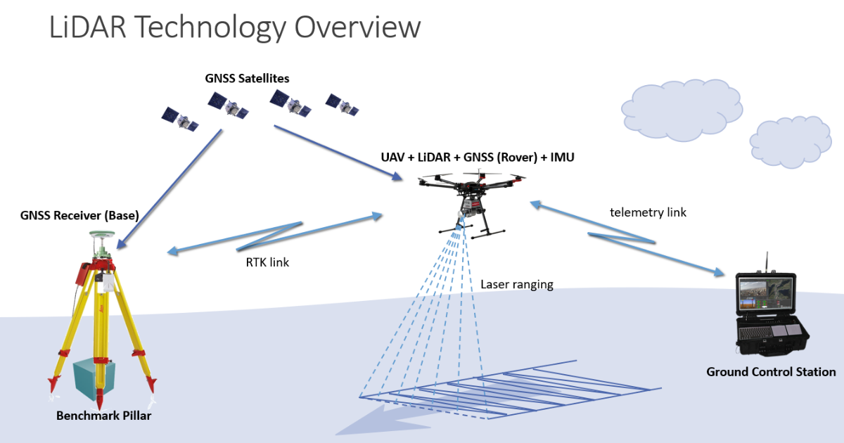
Light Detection and Ranging (LiDAR)
Light Detection and Ranging (LiDAR) is an all-round solution for measuring all target parameters like range, velocity, and chemical constituents. It projects laser pulses in the direction of the object and calculates the duration it takes for the reflected pulse to come back. The LIDAR takes help of the time recorded to measure the distance and collect further data.
A LIDAR consists of a detector, receiver optics, transmitter optics, and a transmitting laser source. LIDAR comes in different configurations; the laser source and the detection method can be changed according to requirements. Furthermore, it aids in creating intricate and comprehensive 3D maps of the nearby surroundings. The technology has gained significant popularity and widespread application in various fields due to its ability to accurately capture the shape and structure of objects and terrain.
These survey instruments play a crucial role in ensuring accuracy, proper alignment, and efficient construction processes, ultimately contributing to successful construction projects across the country. By leveraging the power of advanced surveying technology, construction professionals can optimise resource allocation, reduce costs, and mitigate risks, delivering high-quality structures that meet the needs of communities and contribute to sustainable development.
Key Takeaways
- Surveying is a crucial foundation for successful construction projects, providing vital information about the land, boundaries, and legal requirements.
- Surveyors assess topography and natural features, enabling stable foundation design and proper infrastructure connection.
- Detailed surveying maps serve as guides for architects, engineers, and construction teams, facilitating informed decision-making during the project.
- Key surveying instruments like Total Stations, Theodolites, GPS, and LiDAR enhance accuracy and efficiency in construction processes.
- Surveying ensures accurate planning, optimal design, and compliance with legal boundaries, avoiding disputes and delays.
- Surveyors' construction layout and control services ensure the accurate positioning and alignment of structures, providing precise guidance throughout the construction process.
- Surveying plays a crucial role in safety and risk mitigation, identifying hazards, and monitoring construction for a secure working environment.